If I were a Texas mountain, I’d feel lonely. Contrary to the old adage that if God had wanted Texans to ski, he would’ve given them mountains, Texas does have 18 mountain ranges, none of them Texas-sized and all of them in the state’s remote southwestern corner. But Texas suffers the indignity of having to share its biggest and highest range with New Mexico: the Guadalupe Mountains, topping off at 8,751 feet, a mile higher than the desert that surrounds this island in the sky.
Although the Guadalupe Mountains are not widely known, not even in Texas, the state acquired them about 400 million years ago and they have been inhabited for 10,000 years—by prehistoric tribes known as Basketmakers, Mescalero Apaches, Spanish conquistadores, Anglo ranchers, park rangers and backpackers.
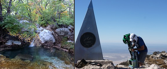
In 1858 Pinery Station was constructed at the mouth of Pine Springs Canyon for the Butterfield Overland Mail Service, which pioneered mail delivery throughout the Southwest. A century later, American Airlines placed a weird triangular steel monument atop Guadalupe Peak commemorating the centennial of the Pinery. The mail route crossed Guadalupe Pass, which in the 20th century became the subject of intense controversy due to an abortive plan to run a railroad across it.
In 1869 a contingent of New Mexico’s Buffalo Soldiers finally chased the Apaches out of the mountains and made them safe for the thieves and bandits who continued for decades to share the region with a handful of ranchers as well as prospectors chasing myths of buried gold. In 1972, with a rancher’s gift of 6,000 acres and another 80,000 purchased acres, the mountains became a national park.
New Mexicans who ridicule Texas skiers are among the many who resent the fourth Texas invasion. The first three invasions were led by soldiers and politicians, the current one by tourists armed only with drawls and dollars, but these currencies can be as devastating to traditional New Mexico cultures as the armed forces who invaded in the 19th century. So in a personal effort to balance the scales, my wife and I set out to reverse the direction of economics, history and demographics. We invaded Texas.
In less dramatic terms, we went camping and hiking for a couple of days in the Guadalupe Mountains. We’d been in the mountains on the New Mexico side of the border a couple of times before but had never visited the higher, more rugged and more remote Texas side. Nor had we climbed Guadalupe Peak, the highest mountain in Texas, or seen the beautiful, lush springs hidden in the mountains’ abrupt canyons on the range’s eastern escarpment.
Most things in Texas are bigger than in New Mexico, and natural springs don’t seem to be an exception. The Guadalupe area springs are large, numerous and support entire oases of trees, flowers and birds. Smith Spring has a small waterfall entering it. Manzanita Spring at Frijole Ranch was damned by a ranching pioneer, and old photos in the museum show his family enjoying water sports in the substantial lake. In this arid land, such springs make life possible for people, wildlife and a wide variety of plants and trees, including the rare Texas madrone.
The springs brought prehistoric Indians here, and they allowed the Mescalero Apaches (named for the native mescal cactus that supplied them with food and alcoholic drink) to hide out here and defy the United Sates Army for decades. The springs lured pioneer ranchers and farmers. And today they help the Park Service attract thousands of campers, hikers and backpackers to 80 miles of trails through wooded groves and shadowed canyons, as well as to the steep, rocky slopes of Guadalupe Peak and the vertical cliffs of El Capitan, the icon of the region. On the New Mexico side of the border, water trickling down from the surface of the Guadalupe Mountains mined some of the world’s largest caves, including famed Carlsbad Caverns.
In Legend and Lore of the Guadalupe Mountains, W.C. Jameson, who has written a number of books about the region, which he started exploring as a 14-year-old boy growing up in El Paso, reports that the mountains are considered the world’s foremost example of an exposed fossilized reef. The organic matter that accumulated beneath what was once an inland sea created this reef. It also created the oil and gas deposits in the adjacent Permian Basin, deposits that today are the basis of the economy of both Texas and New Mexico.
These mountains are in the middle of the Chihuahua Desert and they are usually scorchingly hot. When the heat subsides, the winds can blow through with unpleasant, sometimes terrifying strength. When the heat dissipates and the winds calm, winter temperatures sink into the teens. There are only a few ideal times to hike the Guadalupe Mountains, and October-November is the best of them. This is when the deciduous trees color the mountains’ numerous deep canyons with bursts of vivid orange, red and golden leaves.
As nature smiled on us for two perfect days, we hiked up the canyons to Manzanita and Smith springs and then climbed Guadalupe Peak for stunning views of two states and two countries. Somewhere behind us on the mountain trail was a man who looked like an alien refugee from Roswell, with a 50-pound green camera contraption towering above his head. Every three seconds through the hours of hiking his camera atop his head automatically clicked on. He was a Google trail mapper photographing the centennial monument, the trail leading to it and, who knows, possibly my wife and I. When his work goes online in six months, we’ll find out.
That afternoon, high winds were predicted to move in, and we moved out.


Responses to “Island in the sky, Texas style”