
Above ground the area has sinister overtones. There is the nearby Arizona Strip, a narrow stretch of land in the northernmost part of the state where renegade or fundamentalist Mormon communities still practice polygamy and try to evade the law. In recent years, women fleeing that life and young boys cast out of their homes so they won’t compete with the older husbands have drawn attention, concern, and public aid.
Sinister, or worse, is Glen Canyon Dam, built to provide electricity for vast areas of the West but entombing irreplaceable Glen Canyon in the process.
Page, the largest nearby town, was begun in 1958 to accommodate the influx of workers building the dam. The Navajo Nation was persuaded to trade 24 square miles of its land for a larger tract in Utah, and a few dusty streets were etched into the sandy terrain. House trailers and temporary homes sprang up, quickly followed by churches. The latter still dominate the cityscape. In 1975 Page (named after Bureau of Reclamation Commissioner John C. Page) was incorporated. It is now home to some 9,000 residents, many of them involved in the recreation and tourism businesses. Visitors come to play at Lake Powell and to explore other nearby attractions.
Glen Canyon Dam and Lake Powell were cloaked in controversy from their inception. Their existence symbolizes an attitude toward the future of the United States’ western water resources and wilderness areas. For those who think of progress in terms of water diversion, hydroelectric power, and noisy recreation (the roar of speedboat motors and shouts of beer drinkers), these projects have been a success. The manmade lake attracts more than 3 million people annually. For those who grieve the loss of delicate coves, ancient rock art, and other wonders that once rivaled Grand Canyon in mystery and beauty, construction of dam, lake and city remain travesties of the most shortsighted and shocking sort.
Page’s motels are at least as numerous as its churches, and it’s easy to find a place to stay. A few eateries cater to a variety of basic tastes. The town has a number of tour offices, some marketing specialized day trips for photographers. And photographers are attracted to the surrounding desert landscape and nearby slot canyons like flies to honey. As many images as you’ve seen of the undulating multi-colored rock walls winding beneath the desert floor, there’s always a unique angle you can make your own. Plus, just the experience of wandering those magical underground pathways is an unforgettable experience.
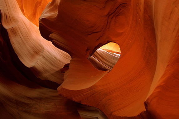
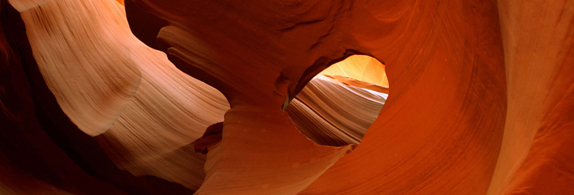
It’s important to remember that this is Navajo land. The Navajo or Diné people still represent the largest segment of the population in the Glen Canyon area. The Navajo reservation is the largest Indian land holding in the country and is home to some 200,000 tribal members. So, although White civilization has imprinted itself rudely upon this place, naming Page for a land commissioner and the lake for the first White man to run the Colorado River through Grand Canyon, the Navajo still control the entrances to the magnificent nearby slot canyons. Although in-town tour companies market widely, it is possible to simply drive to the entrances of Tsé bighánílíní (Upper Antelope) or Hazdistazí (Lower Antelope), pay a small entrance fee, and enter on your own.
Some people will tell you that Lower Antelope was discovered by a 12-year-old Navajo girl out pasturing her family’s sheep. Others will say that’s a story invented to create an intriguing legend. Whatever the truth, it and nearby Upper Antelope are seductive features of a magical land. The whole Colorado Plateau, of course, is dotted with these sinuous slots, many of them only reachable by the hardiest hikers, still others hidden even to them. The slot canyons near Page offer the advantage of being accessible to almost anyone, including young children who thrill to their twists and turns.
Tsé bighánílíní means “the place where water runs through rocks.” It is the most frequently visited of the two canyons, probably because access to it is easier. Its entire length is at ground level, requiring no climbing down into its depths or climbing out again to exit. Shafts of direct sunlight also radiate through openings in the rock, creating those magical beams photographers never tire of holding in their sites. These light beams begin making their appearance around mid-March and disappear in early October.
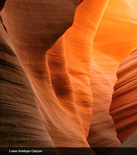
Hazdistazí, meaning “spiral rock arches,” is located only a few miles away. Visiting this slot once required climbing a series of ladders, but metal stairways have now been installed, making exploration easier. This lower canyon is shaped like a V. It is shallower than its upper neighbor and draws fewer visitors. Lighting here is better in the early morning and late afternoon, when the sun slants sideways through its swirls of rock.
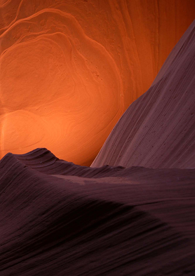
Antelope was formed by the erosion of Navajo Sandstone, due to flash flooding, wind, and diverse sub-aerial processes. Rainwater, especially during the monsoon season, runs into the extensive basin above the slots, picks up speed and sand as it rushes into the narrow passageways, and over time those passageways are eroded away, making the corridors deeper and smoothing the rock’s hard edges so as to form the characteristic flowing shapes. Light filtering in from above illuminates the stones multiple hues.
Access to both Upper and Lower Antelope is strictly controlled, not only as a source of income for the Navajo Nation and the several private tour companies in Page, but because the danger from flash flooding is always a concern. Many people think the greatest danger on the desert comes from heat exposure and thirst. But rain can kill as well. Rainstorms miles away can send torrents of water and mud through narrow slots, devouring everything in their path.
On august 12, 1997, eleven tourists were killed by a flash flood in Lower Antelope. Seven were from France, one from Great Britain, one from Sweden, and two from the US. Very little rain fell at the site that day, but an earlier thunderstorm had dumped a large amount of water into the canyon basin seven miles upstream. A Navajo sheepherder had counseled the group not to enter the canyon, but they gazed up at the clear blue sky and decided to do so anyway. Even the wooden ladders, existent at the time, were swept away. The dead hikers’ bodies were carried all the way to Lake Powell; several were never recovered. The lone survivor of that flood was the group’s guide, Francisco Quintana.
More recently, in July of 2010, several tourists found themselves stranded on a ledge in Upper Antelope when two flash floods roared through. Some were quickly rescued; others had to wait for the floodwaters to recede. A woman and her 9-year-old son were injured as they were carried a distance downstream, but fortunately no fatalities were reported. Today stronger ladder systems have been bolted into place in Lower Antelope, and deployable cargo nets are installed at the top of the canyon. At the fee booth there is a radio that receives reports from the National Weather Service, and alarm horns are stationed in the event they are needed.
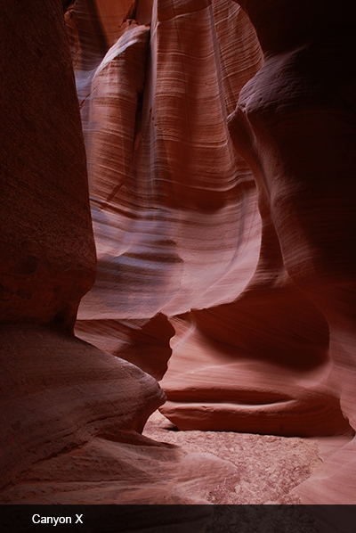
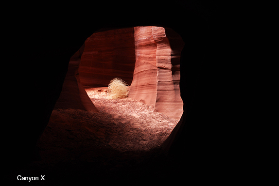
For those intent on extending their exploration of the area’s slots, there is also Canyon X, a slightly deeper, more remote and much less visited destination only a few miles away. This strangely named slot is a 45-minute drive from Page, and although it too lies within the Navajo reservation, access is only available from a single private company, Overland Canyon Tours, that charges heftily for visits limited to 4 or 6 people. Landscape photographer Jackson Bridges leads these groups, and offers helpful tips for the novice photographer.
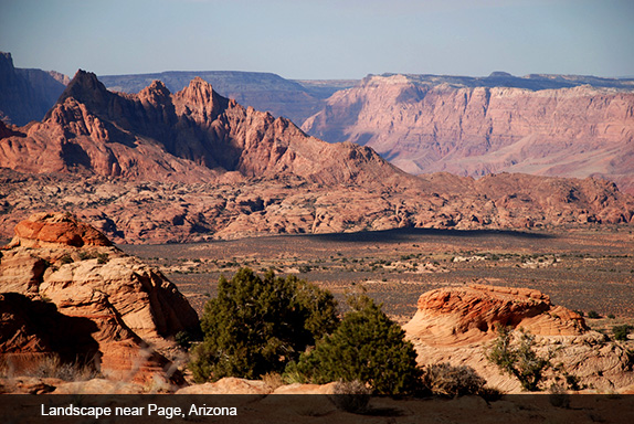
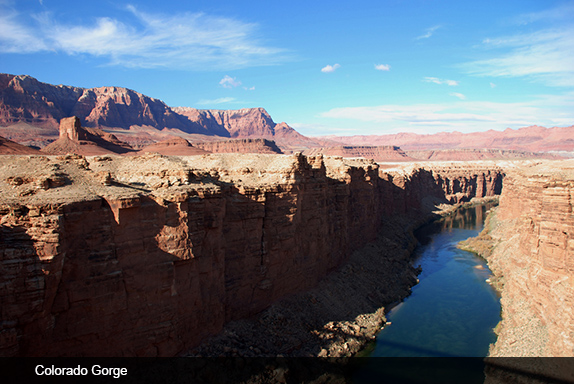
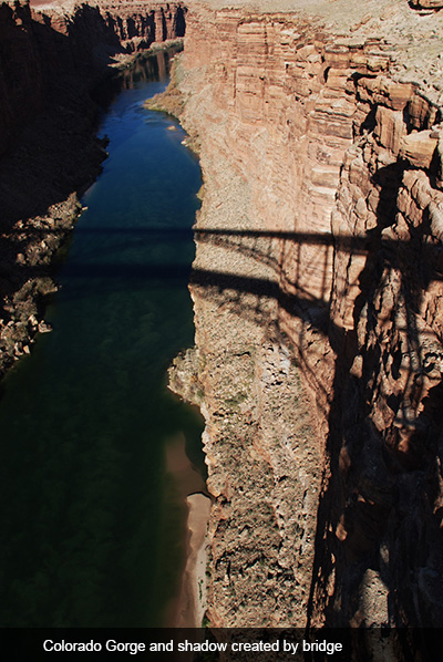
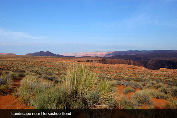
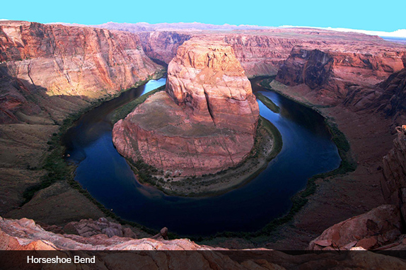
Below and above ground this is magical country. About 4 miles southwest of Page a small sign points to Horseshoe Bend, a Colorado River meander that almost encloses a round butte in its embrace of deep blue water. Accessible via a half-mile hike from US Route #89, this spectacular feature can be viewed from the steep slickrock cliff above. The overlook is 4,200 feet above sea level, and the Colorado River is a thousand feet below. Warning: in order to capture the meander’s full circular beauty, you will need at least a 24mm. wide-angle lens. A bit farther south, there is the dramatic Colorado Gorge with its graceful bridge.
In this era of climate and water crisis, this land of willfully transformed wilderness, makeshift urbanization, hidden slot canyons and beautiful terrain stand as a microcosm of what has been or may yet be preserved in the US American West.

Responses to “Friday Voyage: Glen Canyon Region”